Mayo, Keno, Stewart Crossing and surrounding areas are on evacuation alert and the North Klondike Highway was also intermittently closed due to wildfires.
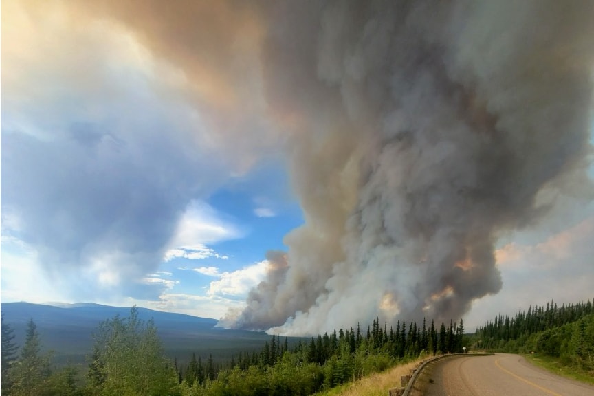
There are 76 wildfires burning in the Yukon according to Wildland Fire Management and more than 70,000 hectares have burned so far this season.
Wildland Fire's present response has largely been dealing with the slew of lightning-caused fires that have ignited in the territory in recent weeks. A July 2 notice from Wildland Fire states that there were only a dozen fires burning in the territory on June 19 but that since then, amid dry forests and thunderstorms 86 new fires started. As of the morning of July 2, 14 fires were prioritized and getting a full response from fire crews with all but two of those being in the Dawson and Mayo fire districts. An end to the widespread lightning is expected this week but high winds that could aggravate burning conditions are likely to persist.
"Wildfire crews have also stopped numerous potentially dangerous wildfires in the forests around Dawson, Mayo, Carmacks, Miner’s Ridge and Watson Lake. These successes have been made possible thanks to hard work from Yukon crews as well as others mobilized from British Columbia. These extra crews represent a nearly 50 per cent increase in Yukon’s initial-attack capacity," the July 2 statement from fire information officer Mike Fancie reads.
Among the notable blazes is the Roaring Fork Fire, discovered June 28 and burning about 320 hectares along the Minto Lake Road 15 km north of Mayo.
"After ignition the fire received an estimated 4 mm of rain. This downtrend in weather will help crews secure the edge of the fire with hose and identify hotspots for extinguishment starting today," Wildland Fire's information page reads.
"Today one initial attack crew, two officers and 20-person unit crew will be assigned to this fire. Precautionary structure protection work will continue on the Minto Lake Road."
The evacuation alert associated with the fire put in place the evening of June 29 covers the Village of Mayo, First Nation of Na-Cho Nyäk Dun C-6 Subdivision, Keno City, km 28 to 108 on the Silver Trail, Duncan Creek Road and Minto Lake Road.
The Wrong Lake fire, currently 14,574 hectares in size according to Wildland Fire, had its progress towards Stewart Crossing stopped yesterday. Stewart Crossing is on evacuation alert due to the fire. Also stemming from smoke due to the Wrong Lake blaze, the North Klondike Highway was only open to vehicles following a pilot car for much of last week. Even the piloted traffic was intermittently stopped as visibility in the smoke makes it unsafe. As of the morning of July 3 Yukon 511 is no longer showing the need for a pilot car but motorists are still being advised to expect delays.
"A downtrend in weather could allow crews to begin working directly on the fire’s edge if it receives rain today. Ignition plans are also in place for long-term containment if conditions allow. Four initial attack crews, four officers, one helicopter and heavy equipment are working on the fire today," the information page reads.
Out-of-territory assistance working on Yukon fire includes: Twelve initial-attack crews, an air-tanker group and an aviation assistant from British Columbia and an ignition specialist trainee from Oregon.
Contact Jim Elliot at jim.elliot@yukon-news.com