The federal and Yukon governments made a pair of flood-related funding announcements on May 6, including money for flood recovery and flood hazard mapping.
The federal government committed to providing the Yukon with three advance payments totalling more than $8.7 million to help cover costs associated with the response and reclamation efforts following spring floods in 2023, 2022 and 2021.
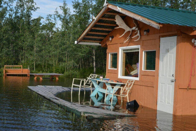
Over the past several years, various parts of the Yukon have been hit hard by floods during the spring and summer months. In May 2023, rising water levels resulted in dozens of residents of the Klondike region being evacuated from their homes and closures on sections of the Dempster and North Klondike highways.
The funding, which is being released through the Disaster Financial Assistance Arrangements (DFAA) program, was announced by Emergency Preparedness Minister Harjit S. Sajjan.
According to a federal government press release, the DFAA program provides financial support “when response and recovery costs exceed what individual provinces or territories could be expected to bear on their own.”
“We are committed to supporting the Yukon in their recovery and rebuilding efforts as communities face the devastating effects of more frequent and severe flooding. As we join forces to confront the growing challenges of climate change, we are committed to building back stronger, more resilient and more sustainable communities,” Sajjan said in a press release.
Also on May 6, Sajjan and the Yukon’s Community Services Minister Richard Mostyn announced a joint investment of $3.5 million to support flood hazard mapping efforts over the next four years, according to a joint press release from the Yukon and Canada governments.
The press release notes that flood hazard maps offer critical data that empowers governments, communities and individuals to identify flood risks and implement efficient measures to minimize the consequences of inundation.
“Today’s announcement marks a significant advance in our shared commitment to enhancing safety and emergency preparedness in Yukon. Flood maps are essential tools in our toolkit that help us better understand and mitigate flood impacts on our communities. Thank you to the Government of Yukon for their ongoing efforts to create a safer and more resilient future for all,” Yukon MP Brendan Hanley said in a press release.
The 14 flood-prone Yukon communities identified for flood hazard mapping over the next four years are Carcross, Carmacks, Dawson, Klondike Valley, Lake Laberge, Marsh Lake, Mayo, Old Crow, Pelly Crossing, Ross River, Tagish, Teslin, Upper Liard and Whitehorse.
Preliminary flood hazard mapping and community involvement processes have concluded for Carmacks, Carcross, Lake Laberge, Marsh Lake and Tagish. The finalized versions of these maps are scheduled for release in the Yukon government’s online “Flood Atlas” hub later this summer.
Future flood hazard mapping initiatives are slated for Dawson City, Klondike Valley and Old Crow, with implementation scheduled for 2024 and 2025.
Flood hazard mapping for all 14 communities is anticipated to be finished by 2028.
Contact Matthew Bossons at matthew.bossons@yukon-news.com